|
|
Exposure Map |
By default, the Exposure Summary Dashboard displays the exposure map. If you do not want to view the map, you can clear the Exposure Map check box in the View Options window.
When the exposure map is visible, the Map Tools appear. You can use the tools to perform various mapping functions, such as selecting the base maps and managing project layers.
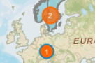
To see various attributes for a single location, zoom in on the map
until you see the number "1" in a circle and then click the
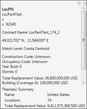
location. Touchstone
displays a window with attribute information; use the vertical scroll
bar to see all the attributes. When you have finished viewing the attributes,
click  to close the window.
If there are multiple locations with the same latitude and longitude information, .you will not be able to view attributes for only one of the locations. For example, if the "2" in the following screen marks two locations with the same latitude and longitude information, zooming in will not split the "2" into two separate locations. |
|
© 2020 AIR Worldwide. All rights reserved. Touchstone 7.0 Updated September 03, 2020 |