|
|
Maps |
|
| This topic is for Touchstone 5.0 and earlier. Maps in Geospatial Analysis 5.1 and Later contains information about Map Tools in version 5.1. |
Maps are available in many locations in Touchstone:
• Exposure or Contract Summary Dashboard
• Contract Details pane
• Analysis results:
• Portfolio Mode: Loss, Data Quality, Hazard, Geospatial, and Loss Groups
• Underwriting Mode: Contract Summary, Clash, Loss, Data Quality (for Score Data diagnostic), and Hazard
Click one of the following links for information about each item:
When you open a map, Touchstone displays a Map Tools tab with a Mapping ribbon that enables you to work with maps in several areas: Base Maps, Map Tools, AIR Provided Layers, Drawing and Selection Tools, Custom-Defined Layers, Project Layers
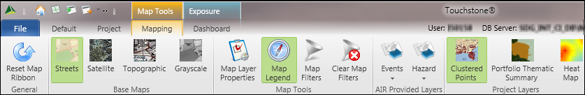
While the Mapping ribbon is available with all maps, the icons that
appear on the ribbon vary according to the function for which you are
viewing the map and, in some cases, according to the mode (Portfolio mode
or Underwriting Contract mode). In some cases, as with the Exposure Summary
Dashboard, the map appears by default. In other cases, you click ![]() (Show/Hide Content Items) in
the sidebar and then select
the Map option in the View Options window. With Data Quality results,
you must first select the Geography view in the Report Detail Viewer window
and then select the Map option in the View Options window.
(Show/Hide Content Items) in
the sidebar and then select
the Map option in the View Options window. With Data Quality results,
you must first select the Geography view in the Report Detail Viewer window
and then select the Map option in the View Options window.
The window containing the exposure or results map includes user controls that, when available, enable you to view and manage map layers, display a map legend, filter locations by peril and geocode, move the map, and zoom in and out of areas on the map. The widgets for map layers and the map legend appear when you select an item—Map Layer Properties or Map Legend— in the Map Tools area on the Mapping ribbon.
To retrieve information for an individual location, move the pointer over the corresponding point on the map and click the location point; a tooltip displays information for the location. For Property Exposure analyses, the tooltip contains total replacement values. For Workers' Compensation analyses, the tooltip displays employee values. If the location is part of a cluster of locations, zoom in on the map until the cluster is broken apart into individual locations. Click X to close the tooltip.
You can move the map by clicking on it and then dragging it in the direction you want to view. In addition, when you move the pointer over the inactive navigation tools in the lower left corner of the exposure map, the navigation tools become active:
• Zoom: In the Zoom bar, click + to zoom in to the map and - to zoom out of an area on the map. You can also drag the slider in the zoom bar to zoom in and out, and zoom in or out using the scroll wheel on the mouse.
To zoom in on an area, hold down Shift and draw a rectangle on the map. |
• Compass: Click on a compass point to move north, south, east, and west on the map. You can also click on one of the compass arcs and then drag to rotate the map.
• Reset
North: Click  to reset the map with north
at the top. This is useful is you have rotated the map.
to reset the map with north
at the top. This is useful is you have rotated the map.
• Full
Extent: Click  to set the map to the full extent
of the exposure data.
to set the map to the full extent
of the exposure data.
|
© 2020 AIR Worldwide. All rights reserved. Touchstone 7.0 Updated September 03, 2020 |