|
|
AIR-Provided Layers |
| This topic is for Touchstone 5.0 and earlier. Maps in Geospatial Analysis 5.1 and Later contains information about Map Tools in version 5.1. |
The AIR-Provided Layers are available only with a Geospatial Analysis license.
This area on the Mapping ribbon enables you to view layers—Events and Hazard—that are included with Touchstone and are available on all maps. The AIR-provided event layers include historical and world scenarios events for Europe, North America, and Asia Pacific. The AIR-provided Hazard layers include Earthquake for Asia Pacific, and Earthquake, Flood, and Tropical Cyclone for North America.
If you license the Verisk Maplecroft Terrorism Risk Index (TRI) layers, you can overlay them on the Exposure Map by selecting AIR-Provided Layers > <region> Terrorism > Maplecroft Terrorism Index_<region>. You can also use the Maplecroft layers in a Geospatial Analysis where you select one or more of the Maplecroft TRI hazard layers via Spatial Outputs > Static Hazard. You can use the layers as part of a ring analysis (for the Terrorism peril) or just run an analysis with them without accumulating any values.
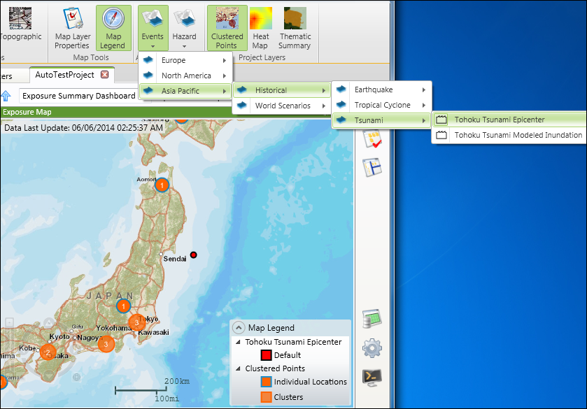
For example,
to view the Tohoku tsunami epicenter relative to your exposure data, select
 Events
> Asia
Pacific > Historical
> Tsunami
> Tohoku
Tsunamic Epicenter.
The map legend now includes the legend for the Tohoku Tsunami. If the
epicenter is hidden under clustered points, zoom in on the area until
you can clearly see the epicenter. When you select a layer, you can also
zoom
in on the layer using Zoom to Layer. For example, select Hazard >
Asia Pacific > Earthquake
> Japan Fault
Lines.
The fault lines appear on the map. Right-click on the layer name and click
Zoom to Layer to
zoom in on the Japan Fault Lines layer.
Events
> Asia
Pacific > Historical
> Tsunami
> Tohoku
Tsunamic Epicenter.
The map legend now includes the legend for the Tohoku Tsunami. If the
epicenter is hidden under clustered points, zoom in on the area until
you can clearly see the epicenter. When you select a layer, you can also
zoom
in on the layer using Zoom to Layer. For example, select Hazard >
Asia Pacific > Earthquake
> Japan Fault
Lines.
The fault lines appear on the map. Right-click on the layer name and click
Zoom to Layer to
zoom in on the Japan Fault Lines layer.
|
© 2020 AIR Worldwide. All rights reserved. Touchstone 7.0 Updated September 03, 2020 |